

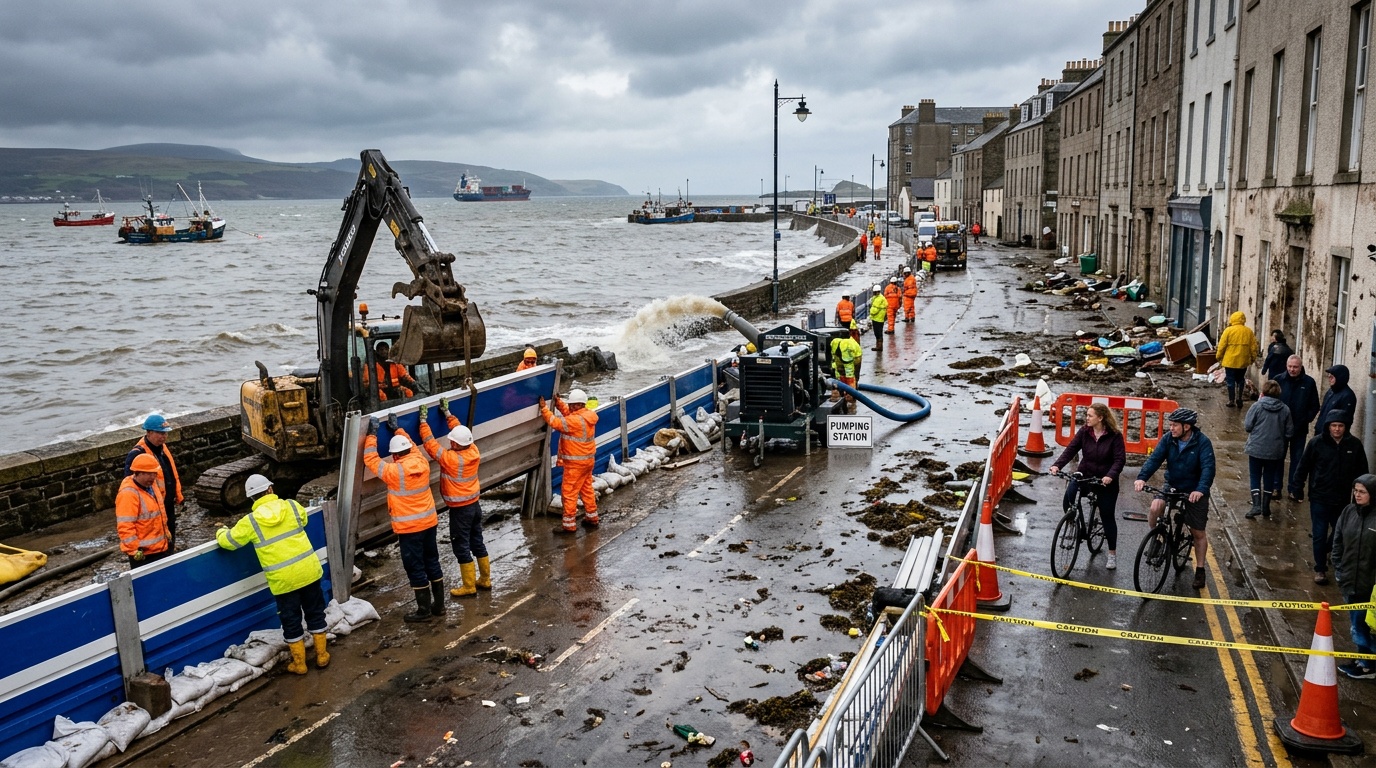
A week of high water changes priorities
Coastal officials entered the week expecting nuisance flooding around predictable high-tide windows. Instead, repeated surges covered roads, entered low buildings, and strained drainage systems. The water returned before crews could fully inspect damage from earlier cycles. That repetition transformed a familiar seasonal risk into an immediate construction priority.
Cities closed vulnerable streets, placed barriers, cleared catch basins, and monitored underground utilities. Emergency teams also tracked saltwater exposure, because corrosion can damage electrical equipment after flooding. Once tides receded, engineers compared observed water levels with existing design assumptions. Their findings helped leaders identify projects that could reduce losses before another extreme tide.
Why extreme tides overwhelm urban systems
Extreme tides occur when astronomical forces raise normal sea levels above typical daily highs. Winds, waves, and low atmospheric pressure can push additional water toward shore. Rising baseline seas then allow similar tide cycles to reach farther inland. Heavy rain worsens flooding when outfalls remain submerged and cannot drain streets efficiently.
Older neighborhoods often face the greatest hydraulic constraints. Many rely on gravity-fed pipes designed for lower seas and smaller paved areas. Water can reverse through those pipes unless cities install valves or pumping stations. This diagnosis shapes the first wave of accelerated projects.
From emergency response to rapid construction
After inspections, public works departments shift crews from temporary control toward permanent repairs. They patch damaged seawalls, reset displaced barriers, and stabilize eroded road shoulders. Cities may also extend contracts that already cover drainage, paving, or marine construction. Existing agreements save time while agencies prepare larger competitive procurements.
Acceleration does not remove engineering reviews or environmental permits. Instead, managers divide complex programs into phases with separate schedules and funding. Crews can clear channels now while designers complete future pump specifications. That staged approach delivers visible protection without abandoning technical safeguards.
Drainage upgrades take center stage
Drainage networks receive early attention because blocked or undersized pipes spread water quickly. Vacuum trucks remove sediment, leaves, and debris from catch basins and conveyance lines. Camera inspections reveal collapsed pipes, leaking joints, and illicit connections beneath streets. Crews then prioritize repairs near hospitals, evacuation routes, schools, and transit hubs.
Cities also install backflow preventers where tides force seawater through stormwater outlets. Larger systems pair tide gates with pumps that move runoff against elevated water. Backup generators keep critical pumps operating during outages. However, every pump requires maintenance, fuel planning, controls, and trained operators.
Roads and waterfront edges rise
Repeated flooding often pushes road elevation projects higher on capital improvement lists. Engineers must preserve driveway access, sidewalk grades, drainage paths, and emergency vehicle clearance. Raising one street can redirect water toward neighboring properties without careful design. Therefore, cities model surrounding flows before approving final elevations.
Along exposed shorelines, teams reinforce seawalls, bulkheads, berms, and deployable flood barriers. They inspect foundations because overtopping water can scour soil behind rigid structures. Movable gates protect road openings while preserving routine access to homes and businesses. Together, these projects connect isolated defenses into a more reliable system.
Natural defenses complement hard infrastructure
Wetlands, dunes, reefs, and living shorelines can reduce wave energy near developed areas. Their vegetation traps sediment, while wider shore profiles create space for moving water. These features also provide habitat and recreational value when planners choose suitable locations. They cannot replace every wall, especially along dense working waterfronts.
Cities increasingly combine natural features with engineered foundations, drainage controls, and raised paths. This hybrid approach can address erosion while maintaining public access. Projects need enough land, compatible sediment, and continuing ecological monitoring. The next challenge involves protecting buildings and essential services behind those shorelines.
Buildings and utilities need targeted protection
Flood-resilience teams inspect fire stations, wastewater plants, substations, libraries, and affordable housing complexes. They elevate electrical panels, relocate mechanical equipment, and seal low wall penetrations. Some buildings receive flood-resistant doors or removable shields across entrances. Facility managers also store chemicals and backup supplies above expected flood levels.
Utility coordination matters because buried networks cross many separate construction sites. Water, power, gas, communications, and transportation agencies must compare schedules before excavation. Coordinated work reduces repeated street closures and prevents newly paved roads from reopening. It also creates a transition from isolated assets toward neighborhood-scale resilience.
Better data sharpens decisions
The tide week gives engineers valuable observations from gauges, cameras, sensors, and field crews. Teams map flood depths, durations, flow directions, and road closure times. They compare those records with forecasts and computer models. Differences can reveal blocked infrastructure, outdated elevations, or unexpected pathways.
Cities then update warning thresholds and publish clearer maps for residents. Text alerts can identify closure periods before commuters reach flooded streets. Public dashboards also show whether pumps, gates, and tide sensors remain operational. Reliable information supports construction choices, but financing determines how quickly projects advance.
Funding and procurement shape the pace
Local capital budgets rarely cover every resilience project identified after a damaging tide. Cities combine municipal bonds, utility fees, state programs, and national grants. Each source carries eligibility rules, deadlines, matching requirements, and reporting duties. Staff must align those conditions with designs that can reach construction promptly.
Leaders may authorize emergency work for immediate hazards while reserving competition for permanent projects. They can also use prequalified contractors, cooperative purchasing, and standardized components. Yet rushed procurement can raise costs or limit accountability. Transparent scopes, public reporting, and independent inspections help preserve trust during acceleration.
Equity guides neighborhood priorities
Flood exposure does not alone determine a community’s ability to recover. Renters, older adults, disabled residents, and lower-income households may face greater displacement risks. Small businesses can lose revenue even when shallow water causes limited structural damage. Cities therefore pair engineering data with health, housing, and mobility indicators.
Resident knowledge improves plans because people observe recurring leaks, shortcuts, and drainage failures. Meetings, surveys, and multilingual alerts help agencies collect that information. Officials must also explain construction disruptions, property impacts, and maintenance responsibilities. That engagement links faster delivery with fairer protection.
A faster program still requires long-term planning
Extreme tides create urgency, but coastal resilience remains a continuing public responsibility. Rising seas will keep changing local flood probabilities, although storm timing remains uncertain. Cities must revisit design heights, maintenance budgets, evacuation plans, and land-use rules regularly. They should measure project performance during every high-water event and publish results.
No project can eliminate flooding, and defenses may shift risk when planners overlook connections. A durable strategy layers warnings, drainage, barriers, natural systems, building upgrades, and development controls. The tide sequence gives cities a practical test of those layers. By acting quickly, communities can turn disruption into safer, better-prepared waterfronts.
